 About F&D Subscribe Back Issues Write Us Copyright Information |
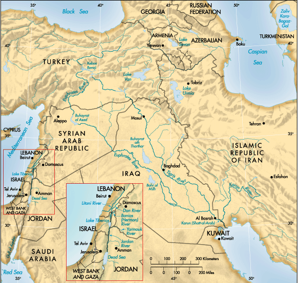
Optimal Water Management in the Middle East and Other Regions Franklin M. Fisher and Hossein Askari Serious conflicts over water pervade the Middle East. How might these be resolved or eased, and how could water management models and international financial institutions help? Water disputes over river basins—the Colorado, the Ganges-Brahmaputra, the Syr Darya-Ana Darya (in Kazakhstan), and the Nile, to name but a few—are a global phenomenon. The Middle East is one of the regions where water scarcity is most apparent. Water scarcity is an important consideration in the peace process between Israel and the Palestinian National Authority (PNA); it has been one of the elements in the continuing dispute between the Islamic Republic of Iran and Iraq; it has been an obstacle in Syrian-Turkish relations and Syrian-Iraqi relations; and, if it is not addressed, it could become a wider problem affecting the Islamic Republic of Iran, Iraq, Israel, Jordan, Lebanon, the PNA, Syria, and Turkey. The foundation for resolving water issues must be the consideration of water as an economic resource. These issues need to be addressed using an appropriate water management (optimization) model, and a credible international organization is needed to assist in the economic management of water in regions around the world. Disputes over water—among different users (including households, farmers, fishermen, and transportation providers), countries, and regions—are most commonly considered to be zero-sum games: one party's gain (in water) is another's loss. Such a view of water allocation can lead only to conflict. But by considering water as an economic good, countries and regions can manage water optimally and differences can be resolved before they lead to conflict. As is true of any economic good, water is scarce; but, unfortunately, competitive markets cannot be relied upon to allocate water efficiently. Water markets are usually not competitive, because there are few sources of water and few sellers, and the social and private costs of obtaining and distributing water and the social and private benefits from using it do not coincide. Overview of Middle East water North Africa and the Middle East constitute the driest region in the world. Annually, it has 355 billion cubic meters of renewable water resources, compared with 5,379 billion cubic meters in North America, 4,184 billion cubic meters in sub-Saharan Africa, and 9,985 billon cubic meters in Asia. Currently, this region of 284 million people (5 percent of the world's population) has access to 1 percent of the world's fresh water. There are four major disputes over water in the Middle East: control of the Karun River, or Shatt-al-Arab (Iran and Iraq); the Euphrates River (Turkey, Syria, and Iraq); the Jordan River (Syria, Israel, Lebanon, Jordan, and the PNA); and the coastal and mountain aquifers (Israel and the PNA). (See map below.) These conflicts cause instability in the region, so resolving them would be a good first step in building confidence and in initiating a peace process throughout the region.
|
|
Note: This map was produced by the Map Design Unit of the World Bank Group. The boundaries, colors, denominations, and any other information shown on this map do not imply, on the part of the World Bank Group, any judgment on the legal status of any territory, or any endorsement or acceptance of such boundaries. The Karun, or Shatt-al-Arab, conflict has not been caused by a dispute about providing the people of Iran and Iraq with a source of water for either domestic or agricultural consumption. While these waters certainly do allow for agricultural development, their most important function is to serve as a transit corridor through which goods from the interior can be shipped to the Persian Gulf for export. The conflict has been, up to now, largely a dispute over the river as a border and over who controls access to it, because the river is Iraq's only outlet to the Persian Gulf. The issue of controlling the water of the Euphrates is the second significant source of conflict in the region. Syria and Iraq depend to a large degree on Euphrates water to sustain their agriculture and to meet other requirements for water. Meanwhile, at the headwaters, Turkey is developing the vast Southeastern Anatolia Project, which restricts the flow of the Euphrates. Of the three countries, Turkey is in the strongest position because it controls the river's source (98 percent of the water in the Euphrates is Turkish), while Iraq is the most dependent on the Euphrates. The development going on in Turkey and, to a lesser extent, in Syria alarms the Iraqi government, which sees its portion of this shared resource dwindling annually. The use of the Jordan River creates a third set of complex relationships, claims, and dependencies. Its four tributaries, and thus its origins, are in several nations. The Yarmouk River originates in Syria, the Banias in Israeli-occupied Syria, the Hasbani in Lebanon, and the Dan in Israel. The Jordan River itself can be claimed, at least in part, by Israel, Syria, Jordan, and the Palestinians. The intersection of so many interests and tensions amid outright political hostility among the actors creates a potential flashpoint. The aquifers in Palestinian-controlled territories, and particularly the mountain aquifer, are the fourth major source of water-related disputes in the Middle East. The Palestinians claim the right to use this water by virtue of their sovereignty over the territories. Israelis claim that by pumping water that would naturally emerge in Israel and that has historically been extracted there (even before the creation of the state of Israel in 1948); they are simply taking what is theirs. The issue is all the more delicate because of the slow destruction of the coastal aquifer owing to salt water intrusion caused by overpumping and because the areas in the mountain aquifer from which water can most efficiently be pumped tend to be near the Green Line separating the Israelis from the Palestinians. The optimization model The optimization model created by Fisher and others (2000)—known as the Water Allocation System (WAS)—allocates water so as to maximize the net benefits to all consumers, subject to constraints. When such maximization of benefits involves one or more constraints, a system of "shadow" values is involved in the solution. The shadow value associated with a particular constraint shows the extent to which the net benefits from water usage would increase if that constraint were relaxed. For example, where a pipeline's capacity is limited, the associated shadow value shows how much benefits would increase if capacity were slightly increased—this is the amount that those benefiting would be willing to pay for such an increase in capacity. The shadow value of water at a particular location shows the increase in systemwide benefits that would occur if an additional cubic meter of water were available at that location. The shadow value of water in a given location does not generally equal the direct cost of providing it there. Consider a limited water source whose pumping costs are zero. If demand for water from that source is sufficiently high, the shadow value of that water will not be zero—benefits to water users would be increased if more water were available from that source. When demand at the source exceeds capacity, it is not costless to provide a particular user with an additional unit of water. That water can be provided only by depriving some other user of the benefits of the water—that loss of benefits represents an opportunity cost. In other words, scarce resources have positive values and positive prices even if their direct cost of production is zero. Such a positive value—the shadow value of the water in situ (where it is found)—is called a "scarcity rent." The general results are as follows:
The WAS model can be applied to districts within a country or to two or more countries that have interdependent water supplies, water demands, water costs, and related water infrastructures. The geographical region under management is divided into a number of districts. Within each district, demand curves for water are defined for household use, industrial use, and agricultural use. The annual renewable amount of water from each source is taken into account, as is the pumping cost. Allowance is made for recycling of wastewater and interdistrict conveyance. Environmental issues are handled in several ways. First, water extraction is restricted to annual renewable amounts; second, an effluent charge can be imposed on households and industry; and, third, the use of recycled water in agriculture (as opposed to other, competing uses) can be restricted. The model permits experimentation with different assumptions about the infrastructure that will be in place in the future—such as the creation of seawater desalination plants in any district that has a seacoast. The analyst specifies the national and regional policies toward water that are desired. The model does not make water policy. The analyst imposes his or her values or policies on the model, which then respects them absolutely. The WAS model provides the analyst with the means to examine how his or her policies can be efficiently implemented and what the consequences would be. The WAS model allocates the available water so as to maximize net benefits, providing the analyst with optimal water allocations and shadow values. Among other things, the model is a powerful tool for analyzing the costs and benefits of various infrastructure projects. Separate models of this kind have now been built for Israel, Jordan, and the PNA to help them study aspects of a variety of projects, including the following:
Beyond such uses for more efficient water management, however, WAS models could be used to assist in water negotiations and to foster cooperation by creating win-win situations. These uses can be briefly described as follows:
A water treaty that merely defines the parties' water ownership can become badly out of date as situations change. By contrast, an agreement to trade in water permits, as described, provides a flexible way of adjusting water-use allocations, with all parties benefiting from the adjustment. This can prevent water from becoming a source of new or reawakening tension. For a region to fully achieve these benefits, it is appropriate to include all countries whose water conditions are interdependent and to construct a multiyear model, because withdrawals from aquifers today have important implications for water supply in the future. A global opportunity for the World Bank There is very little in the body of international law that can be used effectively to resolve regional water disputes. On the one hand, countries waste their precious water resources, largely on agriculture, with little regard for their actions' implications for the quantity and quality of water that will be available tomorrow and almost no regard for the impacts on their neighbors. On the other hand, when water scarcity rears its ugly head, countries are ready to do battle over their sovereign rights, heritage, and national security. It remains clear, however, that better domestic water management can prevent, or at least significantly delay, such crises; regional water management may postpone such crises indefinitely; and if all else fails, countries with access to the sea can evaluate the costs of desalination to obtain an upper limit on the cost of additional water supplies. The availability of, and access to, water should be addressed as an economic issue and not be allowed to become politicized, which would make the issues harder to resolve. Political differences invariably invoke nationalism, thereby increasing the likelihood of military conflicts. The World Bank is the leading institution with the potential to ameliorate the global water problem. The Bank finances water projects including dams, irrigation schemes, general water resource development, electricity generation and distribution, and much more. Its agricultural projects in a country affect water demand, which, in turn, may affect water supplies in other countries if their water resources are interdependent. All of this determines water availability for future generations. The World Bank should implement a holistic approach to water and water-related projects, as was recommended in the Bank's water resources management policy (see World Bank, 1993), with member countries supporting these efforts and viewing water disputes in monetary terms. First, the Bank should use and promote the use of WAS-type models to assist all countries with domestic water management to optimize the use of available water. Second, the Bank and the countries involved should recognize that some "nonwater" projects, such as those in agriculture (for example, those involving the use of fertilizers or pesticides), have implications for a country's water supply and may also have an impact on water supplies in other countries. Third, the Bank should use similar WAS-type models for regions to address regional water issues in countries that are water interdependent and in situations where some countries have water surpluses while others have deficits. Fourth, the Bank should provide a continuous forum for countries with interdependent water resources to discuss the results of regional water-optimization-management models. Fifth, the Bank should foster cooperation—in particular, by facilitating the sale of water permits among countries as mentioned above. Sixth, where countries and regions are following its prescriptions and shortages still persist, the Bank should provide some of the financial resources necessary for efficient large-scale desalination projects. The World Bank has been involved in water and sanitation issues for a considerable period and acknowledges their importance by noting that one billion people do not have access to safe water and two billion lack adequate sanitation. In 2000, the World Bank was involved in 92 water supply and sanitation investment projects and had a total capital commitment to them of more than $6 billion. Finally, as with almost anything else, it would be better for the World Bank and the affected regions and countries to adopt such an approach sooner rather than later. The size of the problem will be smaller and the difficulties surrounding it more manageable while there are viable options. This is especially true for water projects in regions where pumping today from underground aquifers, both replenishable and especially nonreplenishable ones, will have a major impact on tomorrow's water availability. Before water problems become serious, they are more likely to be seen as economic rather than political; thus, the earlier potential water disputes are addressed, the more likely it is that they will be resolved efficiently and peacefully. The use of optimizing models and the exchange of water permits can greatly assist in such resolution.
Our discussion of the optimization model (Water Allocation System) is based on, and borrows heavily from, Franklin M. Fisher and others, 2000, "Optimal Water Management and Conflict Resolution: The Middle East Water Project" (unpublished; Cambridge, Massachusetts: Massachusetts Institute of Technology); and, as regards water in the wider Middle East context, we refer to Hossein Askari and Catherine Brown, 2000, "Water Management, Middle East Peace and a Role for the World Bank" (unpublished; Washington: George Washington University).
References:
World Bank, 1993, Water Resources Management: A World Bank Policy Paper (Washington). ———, 1998, From Scarcity to Security: Averting a Water Crisis in the Middle East and North Africa (Washington).
|